Day 39: Around Uluru
This morning we awoke early and headed off to the airport. For me, this leg would be different for two reasons. One, it would be my first domestic flight since I flew to Chicago, and two, Mary and Madi would also be flying with us. What ended up being the most different was the flight check in. Qantas domestic flights use an automated check in system, which only has one assistant for every dozen or so passengers. The machines print your boarding passes and even luggage tags. You weigh and send the bags off yourself. The airport was very quiet, so everything went very smoothly, and there was no customs to deal with. We got breakfast in the lounge, and soon we were walking across the tarmac and up the stairs onto the plane.
The flight went quickly, and after a quick nap, we were descending into the Ayers Rock airport. For those of you confused by the dual names, “Uluru” is the official aboriginal name of the big rock in the desert, and “Ayers Rock” is what European explorers called it. It was long called “Ayers Rock” by westerns, but now many are switching to “Uluru” to be more respectful to this scared aboriginal site. During our descent, the first thing we saw out of the windows was not Uluru, but Kata Tjuta, another rock formation made of several rock outcroppings, smaller than Uluru, but still huge. We flew very near this formation, and its majestic nature confirmed our desires to hike there tomorrow. Further away, we could see Uluru, which was simply massive, as it looked big despite our far distance.
When we landed, we were definitely in the outback. Every direction there was nothing but red dirt, dry bushes, and small trees. The land was almost perfectly flat, with the exception of the tiniest hills and Uluru in the distance. Furthermore, there is pretty much no civilization around. The airport has one runway and small terminal. A few miles away is the “town” of Yulara, which is actually just Ayers Rock Resort, a collection of hotels, campgrounds, and a few stores, all owned by the same company. There is one petrol station, which doesn’t even bother to put up the prices, as its nearest competition is probably hundreds of miles away. The nearest true town is Alice Springs, a full 447km (278mi) away, a four hour drive.

The rock is visible no matter where you are here.

It is absolutely impressive. It is still more than ten miles away at this point.
We are staying in a cabin on the campgrounds. We had planned to camp in a tent, but when we found out the lows were around freezing, we decided to go with a heated building. Our cabin holds six people, or so they say. It is comprised of three rooms, one with a full sized bed, one with two bunk beds, and one common room, totaling 250 or fewer square feet. The patio in front of the cabin may be bigger than the cabin itself. We drove over to find some food, and found all two of the restaurants closed, as it was 2:30pm, so we went in to the grocery store and bought supplies to make sandwiches. Bananas were $9/lb!
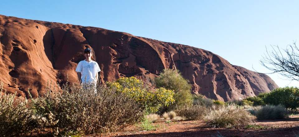
After lunch, we drove over to Uluru (it’s not like there was anything else to do!). The closer we got, the more impressive it became. The campsites are about 20km away from the rock, so it was a bit of a drive to get there. It also seems to play optical illusions. At first, Uluru was just a huge rock in the distance, but of no determinate size. As we moved forward, it just kept getting bigger and bigger until it was towering over us with sheer cliff faces. But then we got even closer, and it seemed to the stretching out; the bottom was reaching us faster than the top. It turns out that Uluru does not have sheer cliff faces, but rather sloping sides, some very steep, some more gradual. When we were almost there, we could make out the trail where people were climbing to the top. It seemed impossibly steep, but once again, as we got closer it became clear that while it was steep, it would not be impossible.
Tomorrow we would climb to the top, so today we decided to hike around the base. It was a 10km (6.2mi) loop around the base, so we knew we would need to more quickly to make it back in time for sunset. As we began walking, we noticed that there were many signs marking certain areas as sacred, and asking us not to enter or take pictures. There were so many of these signs that it seemed the entire hike would be near sacred areas. We walked at a good distance from the rock, which granted good views of it as a whole, but did not give close up detail. After a ways, Mary and Madi were getting tired, and certainly wouldn’t make it around by sunset, so Greg turned around with them and headed back for the car. I continued going forward to complete the circuit, but I knew I would have to move quickly. Soon after I left them, I came to one of the landmarks on the map, an emergency alarm station. Unfortunately, not only would the alarm not be monitored after park hours, but this particular one was completely out of order. Luckily, I had no emergency. I kept going, and one of the coolest things I came to was the shady side. The sun was low enough, and the rock big enough, that there was a hard line between light and dark. On one side there was full sun, on the other complete shade. The weather was absolutely perfect in the sun, 21C (70F), and I thought it would get too cool in the complete shade, but it was actually quite nice, definitely still in the 60s.

Greg and Madi standing in front of the trailhead for the climb to the top.

Going around, it keeps changing as you see new valleys or designs.

I don't think I've ever seen a more staged shot…

Incredible

Passing over to the dark side.
This half of the walk was much nicer as well. Almost the entire time I was walking within 100 yards of the rock, which meant I got amazing up close views of the many hills and valleys, lines and breaks. At a few points, the trail even passed over a flat section of the rock along the bottom. Also, just after my turn to the dark side, the “sacred” signs stopped, and I was completely free to take pictures wherever. One of the sadder parts was a small inlet that had aboriginal drawings who-knows-how-many years old. They were nearly impossible to see thanks to the hundreds of scribbles by indecent tourists.
By this time, I was booking it, because although I could not see the sun, I knew it was getting lower, and I didn’t know exactly how far it was to the end. When I came back to the light side, I could see that the sun was getting low indeed, and I redoubled my efforts. Without running, I went as quickly as I could, eventually making it back to the carpark less than 30 minutes before sunset. Greg, Mary, and Madi had been back for a while, and were doing test runs partially up the rock, to where a support chain started. Mary and Madi had previously been unsuccessful, unable to overcome their fears and go up. I decided to give it a try, and despite it being rather steep, I did not find it scary, as my feet had perfect grip. Mary and Madi tried once more, but could not make it. By this time it was nearly sunset, so instead of driving away to view Uluru from a distance, we stayed where we were on it and looked out over the outback. The sunset was beautiful, and just to the left of the sun we could see Kata Tjuta, which made an awesome silhouette. When the sun dipped below the horizon, we headed back down and back to our cabin. Going down the rock was actually slightly scarier than going up, as you could see where you might fall, but it was still fine.

The only muddy section of trail.

This section was definitely sheer.

Passing back into the light.

Lets see if we are going to make it tomorrow.

This is as far up as Mary and Madi got. If you look at the last picture, this is about where those rocks on the left end.

Sunset with Kata Tjuta in the background.
Back near the campgrounds, we grabbed dinner and set up our beds. Before Madi had to go to bed, we drove out again, about halfway to the national park. There, we were away from the few lights of the resort, and hundreds of miles from any major light source. The stars were absolutely amazing, I have never seen so many. You could see hundreds of times more than on a clear night back home, and to top it all off, you could see the glow of the entire Milky Way behind them. Unfortunately, I was having quite a bit of trouble getting any pictures of them, before finally realizing that I had left my lens cap on!

It is hard to get a good star shot, even with the lens cap off. You can somewhat see the Milky Way in the background. It was way better in person.
Wow, that is a spectacular place. As usual, your pictures are great. We are looking forward to the ones from the hike up Uluru. Also, we want to see a picture of the 3 room cabin that is only 250 sq ft.
Wow, Grandma says that bananas are now selling for 55 cents per pound in Arizona. We thought this was high until we read your post.
Wow!! That’s about the best word that describes where you are. We are really looking forward to tomorrows pictures. I am amazed at how clear it is!!!