Day 47: “Planned”
Today we had a plan. Last night we had set down after dinner and figured out the few things we wanted to do, and this morning we were up and ready to go. Our first stop was Mt Tauhara, a small mountain outside of Taupo. We didn’t really know what the hike entailed, we just saw a short hike there on the map and figured it probably went to the top.
When the road we were on turned to dirt and had a small parking lot, we decided to get out and see if we could find the trail before braving the narrow dirt road. It is a good thing that we didn’t drive on, because we soon found a sign that said to follow the posts for the trail. The “trail” consisted of stepping over a fence into someone’s sheep pasture and climbing the hill towards the mountain. There were no sheep around, but they had left little presents all over the pasture for us to avoid.

The trail goes through the fence?
We climbed high up the hill through the pasture, hopping several fences along the way. We had good views of the city and surrounding countryside, but the cold wind bit at us as we climbed. Finally, we reached the tree line, which got us out of the wind. It was still cold in the forest, but the steep climb kept my core body warm, if my hands and ears were a tad bit freezing. The climb wasn’t quite as steep as the stairs in Nepal, but it was close. Over the course of about 5km (3.1mi), we gained 500m (1640ft) in elevation. Through the trees we climbed all the way to the top of the mountain, which had several peaks. Of course, our trail went to the highest one. The trail was clearly not well traveled, as it was quite narrow. Almost the entire time I had vegetation brushing me from both sides of the trail, and several times I hit my head on branches above. Large swaths of the trail went along the side of the mountain, which meant steep drop offs to one side of the trail. With vegetation pushing you from one side, and a drop threatening from another, balance was required to stay on the trail.

Crossing another fence.

The dense forest.
After huffing and puffing up the steep trail for over an hour, we finally reached the top. From there, we had breathtaking views of the cloud covering the top of the mountain, as well as the small survey station placed there. Thus, after a short snack break, we started to make our way back down. Despite having to avoid slipping, we made our way down in less than half the time we went up. Even though we didn’t get views from the top, the hike was definitely worth it. There were several great views of the countryside along the way, and the forest was stunning. Much like yesterday, it was super thick and green, full of moss and huge trees, including some of the widest pines I have ever seen.

We made it to the top! Look at that view!

There was some major erosion along the trail.

Once we were below the clouds, the views were awesome.

Greg

Me!
Our hike completed, we ate lunch and then made our way into town. There, we reloaded on groceries and spent a while looking at souvenirs and such. Not very exciting. From there, we made our way north once more towards Rotorua. Along the way, we saw some awesome looking hills in the distance, so we turned down a side road and made our way towards them. If the pastures near where we had hiked looked quite possibly just like what you would think New Zealand would look like, then where we were now looked impossibly like New Zealand should. The huge rolling hills we stunningly green and covered in sheep, cows, and even deer. Off in the distance you could see mountains and a lake. It was just beautiful. Unfortunately, I could not get any good pictures due to the lighting, but I certainly won’t forget it.

"Pushing" the truck out of the mud.
Almost to Rotorua, we stopped for our second planned activity, one of the many thermal valleys. Getting there took us past several more pastures, but we were soon there. The Waimangu Valley’s many craters and hot spots are some of the newest in the world, with most of the craters and vents formed in an 1886 eruption, while the rest have been formed in subsequent eruptions in 1904, 1917, and 1973.

Sheep! And New Zealand hills!
We arrived around 3:30pm, and we told that we barely had time to go see anything. There was a hike down the hill, which took you past all of the points of interest, and several bus stops that brought you back to the top. We had to make the last bus at 4:40pm, or they would have to come looking for us. Thus, we would only have time to hike down to bus stop 1, an hour away, not 2 or all the way at the lake, the end of the hike. We said that was fine and headed off.
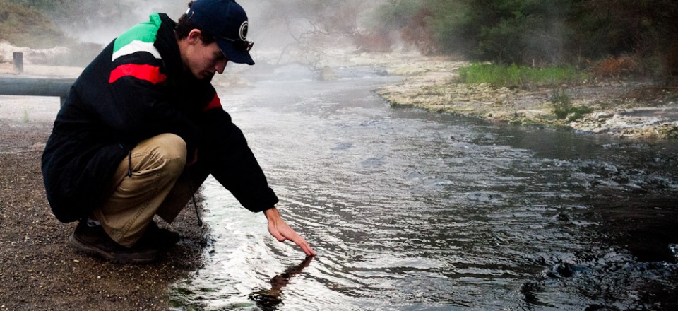
So that is how I got into my first ever jogging tour. Rather than miss two thirds of the park, we decided to just jog in between each point of the interest, thus saving tons of time. The plan worked perfectly. We jogged along, stopping at many points along the way. We saw large, bubbling, steaming, lakes, and tons of small springs shooting out hot water. All of this water flowed into a hot river, which ran down to the lake. We went up to the river, away from any water sources, and the water was still well over 100 degrees F, too hot to keep our fingers in. A bit further down the river we saw a couple of black swans enjoying a warm spa on the river. One crater had huge cliff walls, where you could see how high the water would build up after the rain before draining back into the mountain. The water was a hot sky blue from all of the substances in the water.

The thermal valley was awesome.

The average lake temp is 111 degrees F.

Testing the waters. We found out later that the water can be very acidic.

The crater lake.
Our plan worked well, and we reached bus stop 1 in 20 minutes. We continued on, making it to bus stop 2 with about 15 minutes to spare. As there was little between stop 2 and the lake, we decided not to sprint, but rather to catch the bus as it headed towards the lake. We did just that, and had a few moments by the tranquil lake to take photos before the bus left again. The lake was a major point in the 1886 eruption, and was in fact only about one fifth the size before the eruption. We were quite glad we decided to do the jogging tour, as we definitely saw some awesome nature.

Lake Rotomahana
To spend the night, we had wanted to drive to a nearby lake, where we thought there was a campsite. Unfortunately, after quite a ways driving on back roads, we found out that the way we were to go was through a gated logging road. Instead, we would have to go about 30 minutes around and come in from another direction. We decided to just drive part of the way around and stay in Rotorua, near its lake. Tomorrow we will make it down to the Blue Lake from some hiking.
What a great day! A 5KM hike/climb “up” a mountain (then 5KM back down) followed by a 3KM run and we still had time to relocate our house, shop and do our laundry. Now that was a plan… I’m just not sure what kind. Looking foward to tomorrow’s outing. Time for bed!
You guys are exploring New Zealand at an amazing pace. Grandma and I are getting tired just thinking about a jogging hike! It’s good that the weather is cool there! Enjoyed your pictures and story!